Overview
In 2009, in the former Euregional Historical Centre Sittard-Geleen (now Archives De Domijnen) project was started: presenting digitally and georeferencing all cadastral information, starting with the year 1843 and later ‘filling the gap’ to the year 1970. It was, and still is, mainly a citizen science project, which is facilitated by several archives and individuals.
Since then, many archives and historical societies in the province of Limburg have joined to add data, which is presented online bij the foundation LGGI.
In the website aezel.eu all data is presented in 4 languages: English, French, German and Dutch.
Every parcel is directly related to scans of the original data.
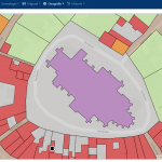
With the buttons ‘search’ and ‘options’ you can search through several ‘layers’ like topographic maps 2016 and 1843, satellite-map or relief-map 2016.
Project partners
Lead partners
Associated partners
Other partners
- Stichting LGGI
- Erfgoedcoöperatie Limburg CEL
- SHEM Eijsden-Margraten
- Gemeentearchief Roermond
- Heemkundevereniging Geleen
- Heemkundevereniging Beek